|
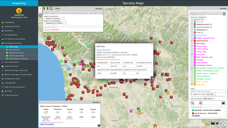
click the image to access the ServiceMap tool |
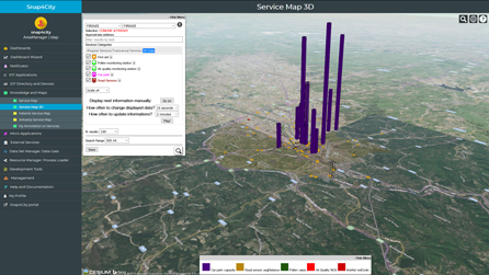
click the image to access the ServiceMap3D tool |
Please note that presently in production on all the KB of Snap4City.org there is the new version of the Km4City ontology and precisely the 1.6.8. This new version includes the concepts for extended Digital Twins and High Level Types: heatmaps, vector field, building, building 3d, typical time trends, floors, entity groups, garden, traffic flow, etc.
Also, in the MicroX the KB provided is the version 1.6.8, since September 2024.
You can ask to have the new version of KB, while the documentation is under update and publication.
he following text is referring to the former version, sorry.
The 1.6.7 version of Km4City ontology reuses standard vocabularies most of the W3C, such as:
- DCTERMS: for metadata Dublin Core Metadata Initiative
- FOAF: friends of a friends
- Good Relation: entities relationships
- iot-lite: IOT Vocabuary
- OTN: Ontology of Transportation Networks
- OWL-Time: time reasoning
- SAREF Smart Appliances REFerence extension for building devices available at https://saref.etsi.org/saref4bldg/
- Schema.org for people and organizations
- SSN: Semantic Sensor Network Ontology (see https://www.w3.org/TR/vocab-ssn/
- WGS84 Datum of Geo-Objects
- GTFS, General Transit Feed Specification, and Transmodel, for public transport infrastructures: lines/rides time schedules, real-time records, paths, etc.;
New vocabularies have been added on 1.6.8 version since September 2024.
- BOT: Building Topology Ontology. https://w3c-lbd-cg.github.io/bot/
- S4CITY: SAREF extension for Smart City. https://saref.etsi.org/saref4city/v1.1.2/
You can have 3D on:
- dashboards via HOW TO: activate tridimensional view on Dashboards, 3D views on Dashboards
- BIM: HOW To: Manage BMP and BIM: main features of openMAINT, BMP, BIM
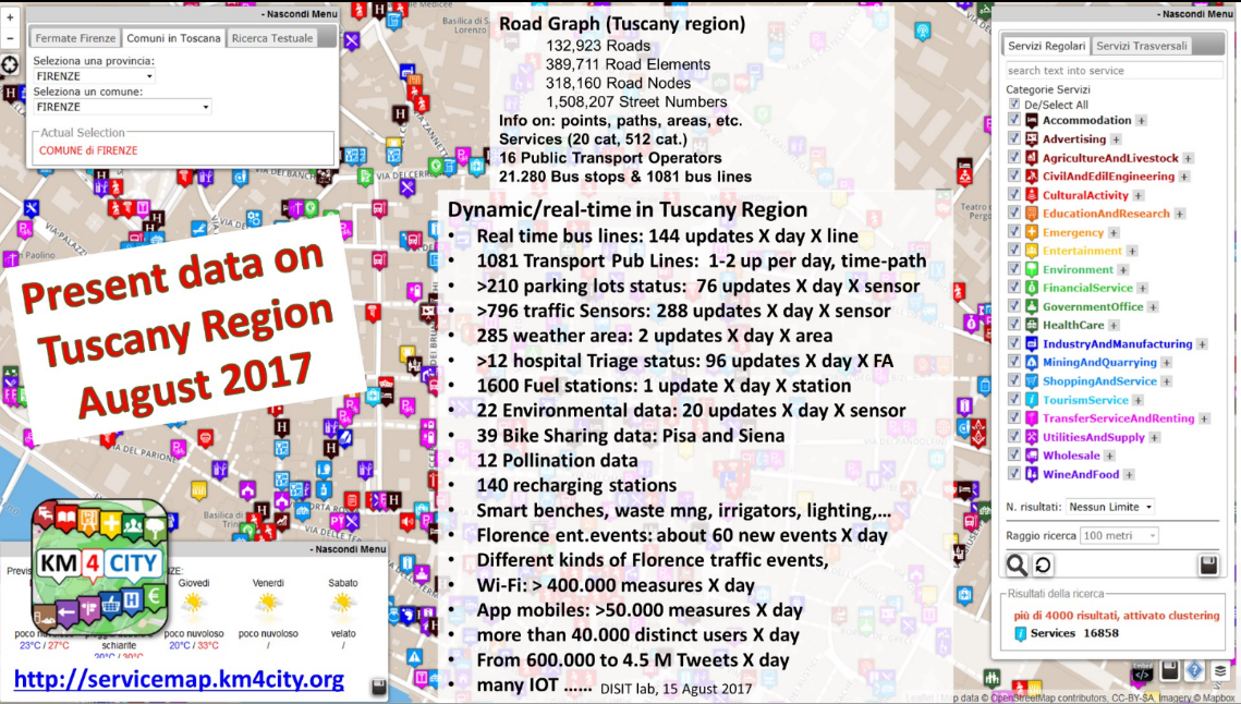
ServiceMap is a tool for navigating on the Knowledge Base by a visual interface and producing samples of the Calls to invoke the Advanced Smart City API. The ServiceMap is a developing tool for generating Advanced Smart City API calls and a learning too to train you on how to pose queries on the KB. The maps are based on leaflet.
see also the video: 
The ServiceMap is a learning tool to
- train you on how to pose queries on the Knowledge Base and API.
- visually browse city map services,
- generating calls of the Advanced Smart City API, which can be received via email,
- recalling and sharing them with other programmers,
- embedding interactive maps into Dashboards, etc.
- simplify the development of Web and Mobile Applications, and the access to the Smart City API for all, also training the developers in their usage.
The ServiceMap allows seeing static and real time data, and also their relationships, exploring geographical queries and passing to the graphs of the Linked Data and semantic model with disit.org">LOG.DISIT.ORG
The ServiceMap allows seeing static and real time data, and also their relationships, exploring geographical queries and passing to the graphs of the Linked Data and semantic model with https://log.disit.org.
The Servicemap support HTTPS.

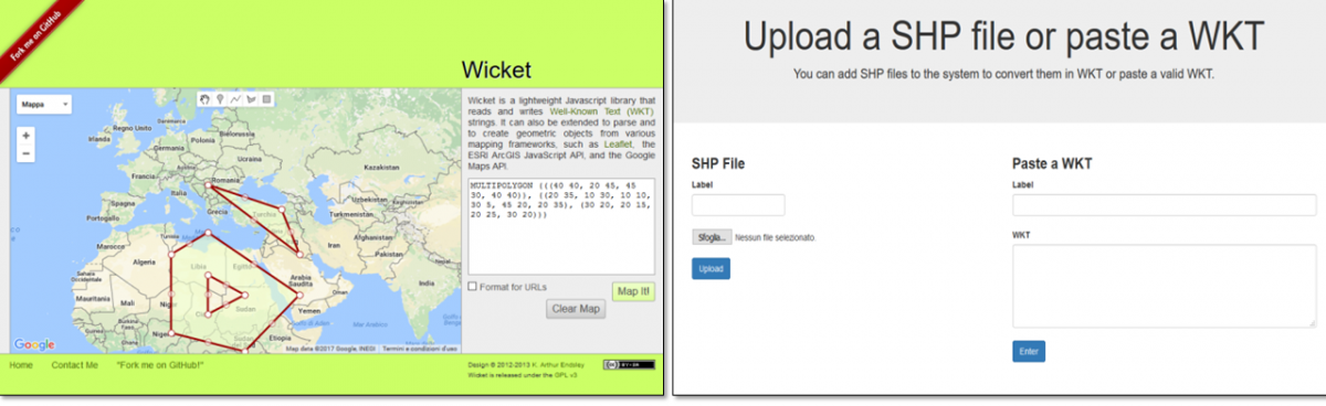
A shape as closed polyline as well as an open polyline as a path can be loaded automatically with a POI on the map via DataGate, or can be:
- Manually created: https://arthur-e.github.io/Wicket/sandbox-gmaps3.html
- loaded via: https://www.km4city.org/wkt/
- see for examples also https://antwerp.snap4city.org/wkt/ https//helsinki.snap4city.org/wkt/
The updated Snap4City mobile development App Kit as open source for developing mobile and web App using Cordoba Apache is accessible on GitHUB from:
https://github.com/disit/snap4cityAppKit
Swagger documentation of Smart City API is on: https://www.km4city.org/swagger/external/index.html
ServiceMap can be accessed from the main menu: "Knowledge and maps--> ServiceMap". Please note that the ServiceMap may be different for each Organization and city to faciliate the positioning of the map in the center of the geo area of the organization. On the other hand, the Smart City API can be generalized by invoking in the final application the SUPER federated Smart City API with the same API call to create Web and Mobile Applications that are independent on the Organization.
Advanced Smart City API is a set of API for exploiting the Knowledge base services. They can be used for:
- creating Web and Mobile Applications
- creating advanced embedded applications, for example call the API to get information from the POS, from Totems, etc.;
- creating micro Applications, HTML5;
- creating dashboards;
- creating IOT applications since they are also accessible as MicroServices.
ServiceMap 3D is a rendering tool showing data and real-time data on a 3D city environment and it can be used for presenting real time data such as status of real time sensors, pollution, traffic flow, temperature, free parking, etc. it is based on Bing. The following figure shows the ServiceMap3D into the Dashboard. The ServiceMap 3D can be programmed to perform a dynamic show of real time data periodically cycling on a set of selected values. For example, showing pollination, traffic, parking, etc., an refreshing the values or cycling among values every XX seconds.
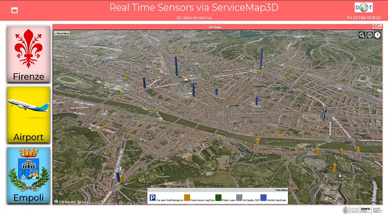
Example: https://dashboard.km4city.org/dashboardSmartCity/view/index.php?iddasboard=MTY2
Entry Login and other URLs for:
- ServiceMap on HTTPS: https://servicemap.snap4city.org
- ServiceMap3D HTTPS: https://servicemap3d.snap4city.org/
- Example https://dashboard.snap4city.org/dashboardSmartCity/view/index.php?iddasboard=MTY2
- Manually created: https://arthur-e.github.io/Wicket/sandbox-gmaps3.html
- WKT: https://www.km4city.org/wkt/
- Km4City Urban Graph Representation
Dedicated entry points:
Documentation and soruce code download:
-
Please note that presently in production on all the KB of Snap4City.org there is the new version of the Km4City ontology and precisely the 1.6.8. This new version includes the concepts for extended Digital Twins and High Level Types: heatmaps, vector field, building, building 3d, typical time trends, floors, entity groups, garden, traffic flow, etc. Also, in the MicroX the KB provided is the version 1.6.8, since September 2024. You can ask to have the new version of KB, while the documentation is under update and publication. The following text is referring to the former version, sorry.
- https://github.com/disit/servicemap
- https://github.com/disit/superservicemap
- https://github.com/disit/servicemap-3d
- https://github.com/disit/linked-open-graph
- From the Open Street Map to the Km4City street graph
- Advanced Smart City API:
-
Km4City ontology version 1.6.8, of September 2024:
- see description on: https://www.snap4city.org//21
- ontology: https://www.snap4city.org/download/video/km4city-1-6-8.zip
- Km4City ontology version 1.6.7, of September 2020:
- Please note that presently in production on all the KB of Snap4City.org there is the new version of the Km4City ontology and precisely the 1.6.8. This new version includes the concepts for extended Digital Twins and High Level Types: heatmaps, vector field, building, building 3d, typical time trends, floors, entity groups, garden, traffic flow, etc. Also, in the MicroX the KB provided is the version 1.6.8, since September 2024. You can ask to have the new version of KB, while the documentation is under update and publication. The following text is referring to the former version, sorry.
- from DISIT lab: https://www.disit.org/6506
- from snap4city: ..............
- PDF ITA https://www.snap4city.org/download/video/DISIT-km4city-City-Ontology-ita-v5-1.pdf
- PDF ENG https://www.snap4city.org/download/video/DISIT-km4city-City-Ontology-eng-v5-1.pdf
Older versions:
- Advanced Smart City API: https://www.snap4city.org/download/video/Km4City_Smart_City_API_Guideline_version_1_Sii-Mobility.pdf
- WLODE on line documentation of Km4City ontology: http://wlode.disit.org/WLODE/extract?url=http://www.disit.org/km4city.rdf
- Km4City Ontology Snap4City Update, v1.6.6: https://www.snap4city.org/download/video/km4city-1-6-6.zip
- Km4City Ontology Descriptive Document, v1.6.6, (ENG): https://www.snap4city.org/download/video/DISIT-km4city-City-Ontology-eng-v5-0.pdf
- Km4City Ontology Descriptive Document, v1.6.6, (ITA): https://www.snap4city.org/download/video/DISIT-km4city-City-Ontology-ita-v5-0.pdf
- Km4City Ontology download (old version): https://www.snap4city.org/download/video/km4city_-_the_Knowledge_Model_4_the_City.zip
- Km4City ontology SVG (old version): https://www.km4city.org/img/Km4City-v1-6-4.svg
- Tutorial for App developers: https://www.disit.org/7044
- Tutorial for Apps: https://www.disit.org/7044
- Example of Applications: https://www.km4city.org/?app
- Example of Web Applications: https://www.km4city.org/webapp/
- Example of Web micro Applications entry: https://www.km4city.org/webapp-new/
- Examples of MicroApplications manual: on Google Drive: https://www.snap4city.org/download/video/Km4city Web App APIv0-4.pdf
Examples ready to be used, they can be also accessed via HTTPS:
- https://servicemap.snap4city.org/
- https://servicemap.snap4city.org/WebAppGrafo/api/v1/?queryId=9c7ff208b0a79cc3b9c39dc6cca77bac&format=html&map=streets&controls=true&description=false&info=false
- https://servicemap.snap4city.org/WebAppGrafo/api/v1/?queryId=e3e5029e1e8e1bafd1df80ba28d66b24&format=html
- https://servicemap.snap4city.org/WebAppGrafo/api/v1/?queryId=8b3c64a7691cd544715bdb49030c4b5a&format=html&controls=true&description=false
- https://www.km4city.org/img/smartf.png
- https://www.km4city.org/img/datasetoverview.png
Articles: [devkit], [RDFcomparison], [Km4CityAPI], [FGCS]