 video:
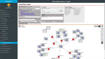
click the image to access the Log.disit.org tool (for registerd users), see also the video
For a more complete overview please read:
- Development Life Cycle: https://www.snap4city.org/download/video/Snap4Tech-Development-Life-Cycle.pdf
- TECHNICAL OVERVIEW: https://www.snap4city.org/download/video/Snap4City-PlatformOverview.pdf
Log.Disit.org is an Open Source tool of DISIT lab for browsing on any Linked Open Data repositories and Linked Data on the world, and browsing also among them independently on their location exploiting also their interconnection via definition in transparent manner. The tool allows sharing configuration and view on the graphs. It facilitates to establish links from the Km4City based KB of the city and the many other linked data in the worlds, for example many Point of interest have links to the definition of VIP people defined in: dbpedia, geonames, etc., thus very important for tourism and cultural applications. FLINT, SPARQL: is a tool for making semantic queries in SPARQL. It is a technical tool that allows at the developers to pose semantic queries on the RDF stores representing the Knowledge Base, one or more. See on the menu the "knowledge base graphs" and "knowledge base queries" toools accessible from the Development Tools menu

Please note that some of the following links could be accessible only for registered users.
Entry Login URL:
Km4City Version 1.6.8
A novel class, named km4c:HighLevelType (HLT), has been introduced in KM4City version 1.6.8 (https://www.disit.org/km4city/schema/). HLT has been introduced to broadly define any physical or conceptual entity relevant for the Smart City domain, like for example city element (buildings, floors, etc.) or fundamental smart city data like origin-destination matrices (ODM), heatmaps, scenarios, traffic flows, etc. Please note that smart city data such as mobility and transport data, energy data, tourism data are in the focus of the main actions of the European Commission on Data Spaces [EU1, EU2]. HLTs are exploited to quickly retrieve associated entities and to associate them with adequate visualization functionalities. Being KM4City enforced into the Snap4City platform, such characteristics allow to link the semantic representation of the data with their visualization enabling improved automatization in the creation of dashboard for data visual analytics. Note also that each entity can be put in relation both to an HLT and to a Service class. Thus, exploiting the already defined Service category hierarchy together with the HLTs is possible to associate an entity with a kind description and with its usage destination. For example, a hotel is related to the km4c:Building HLT and to the km4c:Hotel subclass of the km4c:Accommodation, while a hospital is still associated with the km4c:Building HLT and to the km4c:Public_hospital subclass of the km4c:HealtCare. At the same time, is it possible to have more entities with the same category and different HLT. Similar relations can be instantiated with all the HLTs, e.g., to describe the data mapped in a heatmap of the characteristics of the flows represented in an origin-destination matrix.
HLT is a broad concept that can be used to describe different kinds of entities relevant in the smart city context. It can be seen as a sort of label to add semantic information to data of different kinds. To indicate the specific semantic category a series of subclasses have been defined. Currently KM4City HLT includes km4c:Trajectory_path, km4c:Building (with subclasses km4c:Building3D and km4c:Building_plant), km4c:Entity_group, km4c:Floor, km4c:Heatmap, km4c:Origin_destination_matrix, km4c:Scenario, km4c:Traffic_flow. They correspond to classes: IOT Device/entity, Heatmap, Traffic flow, Origin Destination Matrix, Trajecotry path, Garden, Building plant, Building 3D, Floor, Cycling Path, Entity Group, Typical time trend, Scenario, Vector Field, Parking slot.
When deemed useful, HLT subclasses have been linked by subclass or equivalence relations to classes of other ontologies to improve general interoperability. km4c:Building and km4c:Floor have been subclassed by the s4city:CityObject [s4city]. Moreover, km4c:Floor and km4c:Building have also been made equivalent to the bot:Storey and bot:Building classes from the Building Topology Ontology [bot], respectively.

Other changes wrt 1.6.7
With respect to version 1.6.7, other main changes are the introduction of two new classes, km4c:IndustrialArea and km4c:Urban_furniture, and the update of the class km4c:Traffic_light.
km4c:IndustrialArea describes an industrial area composed of multiple sites. Each site is described with the class industry:Site and related to km4c:IndustrialArea through the object property industry:isPartOfIndustrialArea, both defined in the ontology saref4bldg [saref4bldg]. The inverse object property industry:containsSite is also included.
km4c:Urban_furniture is used to represent any urban furniture like benches, protective elements, accessibility aids, shelters, etc. km4c:Urban_furniture is defined as subclass of km4c:TransferServiceAndRenting and s4city:CityObject.
km4c:Traffic_light has been modified. The class is still used to represent traffic lights, yet it has been made subclass of s4city:CityObject.
---
[EU1] European Commission, “Common European Data Spaces.” Available at https://digital-strategy.ec.europa.eu/en/policies/data-spaces
[EU2] European Commission, “Data Spaces.” Available at https://interoperable-europe.ec.europa.eu/collection/semic-support-centre/data-spaces
[s4city] s4city: SAREF extension for Smart City. Available at https://saref.etsi.org/saref4city/v1.1.2/
[bot] Building Topology Ontology. Available at https://w3c-lbd-cg.github.io/bot/
[saref4bldg] saref4bldg : SAREF extension for building. Available at https://saref.etsi.org/saref4bldg/v1.1.2/
User Manuals and ontologies to download:
-
Km4City ontology version 1.6.8, of September 2024:
- Km4City ontology version 1.6.7, of September 2020:
- Article: https://www.snap4city.org/download/video/LOG.pdf
- SLIDES: https://www.snap4city.org/download/video/LOG-slides.pdf
- Km4City Ontology Snap4City Update, v1.6.6: https://www.snap4city.org/download/video/km4city-1-6-6.zip
- Km4City Ontology Descriptive Document, v1.6.6, (ENG): https://www.snap4city.org/download/video/DISIT-km4city-City-Ontology-eng-v5-0.pdf
- Km4City Ontology Descriptive Document, v1.6.6, (ITA): https://www.snap4city.org/download/video/DISIT-km4city-City-Ontology-ita-v5-0.pdf
- Km4City Ontology download: https://www.snap4city.org/download/video/Km4city%20Web%20App%20APIv0-4.pdf
- Km4City ontology SVG: https://www.km4city.org/img/Km4City-v1-6-4.svg
- WLODE on line documentation of Km4City ontology: http://wlode.disit.org/WLODE/extract?url=http://www.disit.org/km4city.rdf
- Km4City Urban Graph Representation
Examples ready to be used: